- Home
- Technical Indormation
- Soil Types and Technical Description
SOIL SURVEY OF ORIENTAL MINDORO PROVINCE
SOIL MAP: MINDORO PROVINCE PHILIPPINES
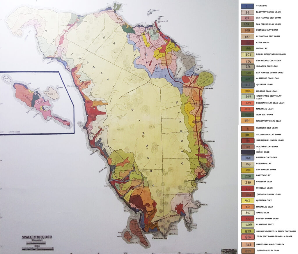
SOIL TYPES OF ORIENTAL MINDORO
(118) Beach Sand
(82) San Manuel Silt Loam
(140) Luisiana Clay Loam
(190) San Manuel Loam
(407) Alaminos Clay Loam
(202) Rough Mountainous Land
(572) Buguey Loamy Sand
(109) Quingua Clay Loam
(190) San Manuel Loam
(829) Maranlig Gravelly Sandy Clay Loam
(202) Rough Mountainous Land
(1) Hydrosol
(118) Beach Sand
(96) San Manuel Sandy Loam
(572) Buguey Loamy Sand
(109) Quingua Clay Loam
(829) Maranlig Gravelly Sandy Clay Loam
(202) Rough Mountainous Land
| (1) Hydrosol |
| (96) San Manuel Sandy Loam |
| (36) Tagaytay Sandy Loam |
| (153) Bolinao Clay |
| (202) Rough Mountainous Land |
(1) Hydrosol
(118) Beach Sand
(572) Buguey Loamy Sand
(276) Bulaoen Clay Loam
(96) San Manuel Sandy Loam
(569) Calumpang Silty Clay Loam
(82) San Manuel Silt Loam
(190) San Manuel Loam
(52) Calumpang Clay Loam
(202) Rough Mountainous Land
(118) Beach Sand
(109) Quingua Clay Loam
(190) San Manuel Loam
(236) San Manuel Clay Loam
(829) Maranlig Gravelly Sandy Clay Loam
(202) Rough Mountainous Land
(118) Beach Sand
(236) San Manuel Clay Loam
(572) Buguey Loamy Sand
(829) Maranlig Gravelly Sandy Clay Loam
(202) Rough Mountainous Land
(1) Hydrosol
(118) Beach Sand
(52) Calumpang Clay Loam
(96) San Manuel Sandy Loam
(190) Sam Manuel Loam
(82) San Manuel Silt Loam
(109) Quingua Clay Loam
(202) Rough Mountainous Land
(829) Maranlig Gravelly Sandy Clay Loam
(109) Quingua Clay Loam
(236) San Manuel Clay Loam
(501) Maranlig Clay
(202) Rough Mountainous Land
(1) Hydrosol
(140) Luisiana Clay Loam
(276) Bulaoen Clay Loam
(236) San Manuel Clay Loam
(96) San Manuel Sandy Loam
(1) Hydrosol
(118) Beach Sand
(865) Banto-Malalag Complex
(506) Mogpog Clay Loam
(156) Lugo Clay
(202) Rough Mountainous Land
(1) Hydrosol
(118) Beach Sand
(82) San Manuel Silt Loam
(109) Quingua Clay Loam
(96) San Manuel Sandy Loam
(102) San Fabian Clay Loam
(236) San Manuel Clay Loam
(829) Maranlig Gravelly Sandy Clay Loam
(202) Rough Mountainous Land
(506) Mogpog Clay Loam
(407) Alaminos Clay Loam
(865) Banto-Malalag Complex
(202) Rough Mountainous Land
(140) Luisiana Clay Loam
(236) San Manuel Clay Loam
(96) San Manuel Sandy Loam
(202) Rough Mountainous Land
(82) San Manuel Silt Loam
(140) Luisiana Clay Loam
(109) Quingua Clay Loam
(202) Rough Mountainous Land
SOILS OF THE PLAINS, VALLEYS & UNDULATING AREAS
The soils of the plains, valleys and undulating areas are developed from young alluvial fans washed down from the surrounding elevated areas. Their color ranges from light brown to dark brown, light reddish brown, reddish brown to dark brown and grayish brown to clay. Belief is generally level, nearly level to undulating. External drainage is good while internal drainage is poor the fair. They are usually found along the courses of rivers and creeks. These soils constitute the most production area in Mindoro Provinces.
Alaminos series are residual soils of volcanic rocks. The surface soils are reddish brown to brick red friable loam to clay loam. The relief is slightly rolling to hilly and mountainous. Drainage is good to excessive.
In places where erosion is serious, rock outcrops as well as highly weathered rocks are found on the surface. Boulders of basalt, diorite, andsite, conglomerates and serpentine rocks present in this series.
The mountainous and hilly regions are either covered with shrubs or secondary forest. The rolling areas are under grass.
Alaminos clay loam (407). The clay loam surface soil is reddish brown to brick red in color. It has columnar structure, perous, sticky when wet and friable when dry. Iron concretions are present. Depth is 35 centimeters.
The subsoil is similar to the surface soil in color and in texture. When dry is it cloddy to course granular in structure. The upper boundary is 35 centimeters and the lower limit is 70 centimeters from the surface.
The substratum has similar physical characteristics as the surface soil. The amount of gravel and iron concretions increases with depth. Sometimes, limestone, basalts and conglomerates are present.
This soil type occupies the lower slopes of San Teodoro extending toward Baco municipality. It has aggregate area of 2,849 hectares.
The principal crops grown are coconuts, bananas and root crops.
Banto soils are developed from igneous rocks, primarily andesite and basalt. The relief is rolling to hilly. External drainage is good to excessive while external drainage is fair.
The area occupied by Banto soils are primarily under secondary and primary forest. A portion though is used as pasture and a few patches are occupied by upland rice as well as some fruit trees.
Bolinao series are primary soils developed from coralline limestone. They are differentiated from other series of limestone origin by their dark brown to red surface soils. The relief is rolling to hilly with some level areas. External drainage is good to excessive while internal drainage is fair. The soils are under grass, secondary and primary forest and crops.
Bolinao clay (153). The profile characteristics of the soil type except for the texture of the surface soil are similar to those of Bolinao clay loam discussed elsewhere in this report.
This soil type occupies the southern tip of the island of Mindoro Provinces, especially in the municipalities of Bulalacao, Oriental Mindoro and Magsaysay, Occidental Mindoro.
Angular and rounded limestone gravels abound on the surface. On the eroded portion, limestone boulders outcrops interfere with tillage operation.
Part of the soil type, however, is planted to coconuts. The rest of the area is either under secondary or primary forest.
Bulaoen soils are primary soils developed from igneous rocks. The relief is flat upland to undulating and rolling with outcrops of gabbro rocks and boulders on the surface. External drainage is good to excessive while internal drainage is fair. The uncultivated portion is under secondary forest while cultivated parts are planted to coconuts, banana, other fruit trees and upland rice. There is only one soil type under the series mapped in Oriental Mindoro.
Bulaoen clay loam (276). The surface soil is clay loam, brown to grayish brown, slightly friable and fine granular in structure. Depth is 25 centimeters. Boundary with the underlying layer is smooth.
The subsoil is clay loam, brown to reddish brown with plenty of gravels and iron concretions. Boulders are embedded in some places. The depth is 45 centimeters from the surface.
The substratum is clay loam, brown to strong brown to reddish brown, massive and friable. It is sticky when wet. Gabbro rocks are present.
The soil type is mapped on the undulating and rolling areas on the eastern part of Calapan and on the rolling portion at Naujan and Pola, Oriental Mindoro. It covers a total area of approximately 8,984 hectares.
The hilly portion at Calapan, Oriental Mindoro is planted to coconuts, some bananas and second growth forest. Coconuts yield and average of 3,000 nuts per hectares. While a limited area of flat upland (plateau) within the soil type is planted to upland rice and corn.
Lugo series are residual soils from calcareous shales. The relief is slightly rolling to rolling. Drainga is good externally but poor internally. Limestone rocks are occasionally present.
There is only one soil type mapped under the series is Mindoro Province.
Lugo clay (156). The clay surface soil is dark gray to black, medium to fine granular, structure, sticky and very plastic when wet, slightly friable when almost dry, fairly rich in organic matter. Limestone rock outcrops are present. Depth is 15 centimeters. Boundary of subsoil is smooth and diffuse.
The clay subsoil, dark brown to yellowish brown, strong coarse granular structure; slightly friable when dry, very plastic when wet. Boundary with underlying layer is smooth and abrupt.
The substratum is silty clay, brownish gray, weak coarse granular structure, gritty, sticky when wet. Limy consolidated shales are present.
The soil type is found on the northwestern tip of Oriental Mindoro Province within the municipality of Puerto Galera with a total area of 1,029 hectares.
The principal crop grown is coconuts which yield 2,800 nuts per hectare. Banana, coffee and some fruit are also grown.
Luisiana soils are developed from basaltic rock materials. The topography is rolling to hilly and mountainous. External drainage is good to excessive while internal drainage is good. The vegetation consists of grass, secondary and primary forests and some crops.
Luisiana clay loam (140). The clay loam surface soil is brown to reddish brown, very friable when dry, sticky when wet, prismatic to columnar to coarse granular is structure. Depth is 25 centimeters.
The subsoil is clay, yellowish brown to light reddish brown, friable and mellow, columnar in structure with reddish purple streaks and light gray or yellow splotches. The upper and lower boundaries are smooth and obscure. Depth is 70 centimeters from the surface.
The substratum is clay, very friable with light gray to yellowish gray to yellow splotches.
The soil type comprises the strips occupying the lower slopes of the rough mountainous land within the municipalities of Baco, Naujan, Victoria, Pola and Socorro, Oriental Mindoro. The total area is about 24,421 hectares.
Coconut is the principal crop grown. Upland rice, banana and other fruit trees are also grown.
Maranlig soils are primary soils derived from basalt and andesite. The relief is rolling to hilly with some level to undulating portions.
Drainage is good excessive externally and fair internally.
The series covers the extensive rolling to hilly areas under secondary forest, some portions under parang and grass and cultivated areas. The cultivated portions are planted to coconut, upland rice, corn, bananas and root crops.
There are three soil types mapped under the series.
Maranlig clay (501). The surface soil is clay, brown to dark reddish brown, slightly friable and compact when dry, sticky and plastic when wet, fine granular structure. Root penetration is easy. Depth is 25 centimeters. Boundary with subsoil is smooth and abrupt.
The subsoil is clay, dark brown to reddish brown, hard and compact when dry, very sticky and plastic when wet. Gravels and stones of various sizes and shapes are well distributed in this layer. The upper to boundary is at 25 centimeters while lower boundary is at 90 centimeters from the surface.
The substratum is clay, reddish brown, sticky and plastic when wet, hard and compact when dry. Gravels and stones of various sizes and shapes at varying degrees of weathering are present.
This soil type is found in Papandayan, Pinamalayan, Oriental Mindoro which occupies a total area of approximately 1,583 hectares.
The principal crop is coconut which yields and average of 3,000 nuts per hectares. Banana with an average yield of 750 bunches per hectares and some root crops are also planted.
Maranlig gravelly sandy clay loam (829). The profile characteristics of this soil type are similar to those of the Maranlig clay discussed elsewhere in this report except from the texture of the surface soil.
This soil type is found as a trip along the lower slopes of the mountainous land extending from north to south in Pinamalayan, Gloria, Bansud, Bongabong, Roxas and Mansalay, Oriental Mindoro and in Calintaan, Rizal and San Jose, Occidental Mindoro. The area occupied is extensive covering approximately 65,150 hectares.
There is not much cultivation on this soil type. Only small patches of coconut fields, Upland rice and root crops are found. The rest of the area is devoted to pasture.
Maranlig loam (818). The profile characteristics of this soil type are similar to those of Maranlig clay discussed elsewhere in this report except for the texture of the surface soil.
This soil type is found in the level to undulating area in Barrio Formon, Bongabong, Oriental Mindoro. The area is very limited about 474 hectares only.
The principal crop crown is upland rice which yields from 20 to 30 cavans of palay to the hectares. Other crops are corn, coconut, banana, sweet potato and other root crops. Banana gave some 400 to 750 bunches per hectares.
San Fabian soils are residual soil of volcanic tuff. The relief is rolling to hilly with some level areas. The external drainage is good to excessive but internal drainage is poor to fair.
A large portion of the area is under secondary forest. The rest is under grass with some portions deviated to kaingin farming where upland rice, root crops and some fruit trees are grown.
Only one soil is mapped in Mindoro Provinces under the series.
San Fabian clay loam (102). The clay loam surface soil is dark brown to dark gray, nutty to cloddy structure, slightly friable when dry and plastic when wet. Gravels are present. The depth is 25 centimeters.
The subsoil is clay loam, grayish brown, granular to nutty structure slightly compact to compact. Depth is 40 centimeters from the surface.
The substratum is clay loam to clay, pale gray to yellowish gray, sticky and plastic when wet and hard and compact and dry. Some gravel is present.
The soil type is found in the rolling hills at Roxas, Oriental Mindoro.
The soil type is not suited for agricultural purpose. Some portions, though, are under kaingin farming and are planted to upland rice and root crops.
Tagaytay soils are developed from volcanic rocks. The relief is generally rolling to hilly. External drainage is good to excessive while internal drainage is fair to good.
The series as mapped in Mindoro Provinces is under grass, second growth forest and some patches of kaingin clearings. Only one soil type is found in the provinces.
Tagaytay sandy loam (36). The surface soil is sandy loam dark brown to nearly black, friable and granular. Root penetrations are easy. The depth is 25 centimeters.
The subsoil is clay loam to clay, dark brown to very dark brown, slightly friable to almost compact. The organic matter content is poor. The upper boundary is 25 centimeters while the lower boundary is 50 centimeters from the surface.
The substratum is light yellowish brown to light grayish brown partly weathered tuffaceous rock extending to a considerable depth.
The soil type covers the gently rolling to hilly areas of Bulalacao and the small islands of Tambaron, Maasin and Buyayao, Oriental Mindoro. It has a total area of approximately 14,130 hectares.
The soil type is at present utilized as pasture for cattle. Some patches are devoted to kaingin farming and are planted to upland rice, root crops and some fruit trees.
Banto – Malalag complex (865). This soil complex is an association of Banto clay loam and Malalag clay loam. These two soils are mixed in intricate pattern that they cannot be indicated separately on a small-scale map. This soil complex has a rolling to hilly and mountainous relief. It is mapped at the mountains of Puerto Galera extending westward to Sitio Cabasingan, Abra de Ilog, Occidental Mindoro and southeastward occupying part of the municipality of San Teodoro. The total area occupied is approximately 3,126 hectares.
The principal vegetation is secondary forest. Areas along the provincial highway are planted to coconuts and bananas.
Strictly speaking, soils under this classification are not true soil in the sense that they are not products of weathering and they do not exhibit profile development. Areas where relief, drainage, accessibility, and others are not favorable for agriculture are also included under miscellaneous land types. In Mindoro Provinces the following constitute the miscellaneous land types; beach sand, hydrosol, riverwash and rough mountainous land types; beach sand, hydrosol, riverwash and rough mountainous land. The total area occupied by these types is approximately 569,573 hectares.
Beach sand (180). This land type occupies the low level areas along the coast of the provinces. The sand consists of quartz, limestone and finely triturated marine shells which accumulate on the beach through wave action. Beach sand is well drained. Crops are grown on this type to a certain extent. Coconuts are usually planted. Depending upon the coarseness of the sand and the availability of irrigation water, this land type can be grown to vegetables and some fruit trees. Beach sand occupies an approximate area of 12,428 hectares.
Hydrosol (1). Salt marshes along the coastal regions in Mindoro Provinces are classified as hydrosol. Such areas are usually flat and are under water most of the time. The total area occupied is approximately 4,710 hectares. The vegetation is made up of mangrove, nipa, palms, bakauan and pagat-pat.
Hydrosol areas are converted into fish ponds are found in Calapan, Naujan, Baco and Puerto Galera, all of Oriental Mindoro and in San Jose, Sablayan, Mamburao and Lubang islands, all of Occidental Mindoro.
Rough Mountainous land (202). The mountain ranges which centrally run along the length of the provinces are classified as rough mountainous land. A large part of this land type is not suitable for agriculture because of its very steep slopes. Small patches of relatively level areas are found throughout this land type, though, which may be properly cultivated and planted to crops. Numerous Kaingin clearings exist at the time of the survey. This kind of cultivation of farming has contributed much to soil erosion problems in the provinces. Runoff became very excessive which caused destruction in the lowlands not only of homes, crops and livestock’s but also of arable lands burying them under rocks and sand.
Rough mountainous land should be utilized solely for forest. Areas cleared should be reforested and the kaingin system of farming must be stopped by all means. Lumber concessioners in the area should be remained to practice selective logging and reforestation.
Once this area is reforested, soil erosion and excessive runoff will be minimized; streams which supply water as well as drain the areas in the lowlands may flow continuously.
This land type covers an approximate area of 547,685 hectares equivalent to 53.46% of the combined area of Mindoro Provinces.
Buguey series, first identified during the reconnaissance soil classification of Cagayan Province, consists of soils developed from recent coastal deposits. The soils are friable and structureless. Root penetration is easy. The relief is generally level. External and internal drainage are good to excessive. Buguey loamy sand is the only soil type mapped under the series.
Buguey loamy sand (572). The surface soil is brownish gray to dark gray brown loamy sand; loose and structureless. The boundary between layers is not distinct. Root penetrates this layer with ease. The average depth is 20 centimeters.
The subsoil is brown to dark brown sand, loose and structureless. Few marine sheel are present in some places. The upper boundary is 20 centimeters while the lower boundary is 150 centimeters from the surface.
The substratum is similar to the subsoil.
The soil type occupies the slightly elevated areas along the coast of Calapan, Naujan, Gloria, Bansud, and Bongabong. It covers and approximates area of 4,631 hectares.
The main crop is coconut. Vegetable and root crops are grown in some areas. Uncultivated areas are covered with different species of shrubs.
Calumpang soils are derived from recent alluvial deposits. The relief is level to slightly undulating. External and internal drainage are poor. Two soil types under the series are mapped in Mindoro Provinces.
Calumpang clay loam (52). The surface soil is light gray clay loam; highly plastic and slightly sticky when wet; hard and compact when dry. It is 10 centimeters deep.
The subsoil is dark gray to very dark brown clay loam; sticky when wet, brittle when dry; with blocky structure. The upper boundary is 10 centimeters while the lower boundary is 40 centimeters from the surface.
The substratum is mottled grayish brown to yellowish brown clay loam to clay; sticky and plastic when wet; gritty. The depth ranges from 40 to 150 centimeters from the surface.
The soil type is mapped in the municipality of Naujan with an approximate area of 5,383 hectares.
The principal crop grown is rice, both lowland and upland. Varieties planted are Camuros and Pinili which yield from 20 to 40 cavans per hectares. Coconut and banana are also grown on the slightly elevated portions.
Calumpang silty clay loam (569). This soil type has similar profile characteristics as of that of Calumpang clay loam except for the texture of the surface soil.
It is mapped just south of the poblacion of Calapan, Oriental Mindoro. The aggregate area occupied is about 3,522 hectares.
The principal crop is lowland rice. Varieties planted are Pinili and Pinursigue which yield from 25 to 50 cavans per hectare. Coconut, banana and corn are planted on slightly elevated portions.
Soils of the series are derived from recent alluvial deposits. The relief is level to nearly level with some portions on depression which remain waterlogged after a continuous heavy rain. Lowland rice, coconut and banana are grown. Only one soil type, Mogpog clay loam, is mapped under the series.
Mogpog clay loam (506). The clay loam surface soil is brown to reddish brown, fine granular structure, with reddish mottling’s. It is slightly sticky and plastic when wet; friable when dry. Boot penetration is fair. The average depth is 25 centimeters. The boundary is smooth and diffuse. The subsoil is clay loam, brown to yellowish brown, slightly compact with reddish brown splotches. The depth is 105 centimeters from the surface. Boundary with substratum is smooth and diffuse.
The substratum is sandy clay loam, yellowish brown, with pale rusty-like streaks. Concretions that produce a black powdery mass are present.
The soil type is mapped in San Teodoro and along the principal highway between this municipality and Puerto Galera. The total area occupied by the soil is 1,306 hectares.
The principal crop grown is lowland rice. Banana and coconut are planted on the slightly elevated portions. The lowland rice is solely dependent upon the rain but gives a satisfactory yield of 40 to 50 cavans per hectare.
The soil series is derived from recent alluvial deposits. The relief is level to slightly undulating. The undulating portions are covered with scrubs or grass while the cultivated area is planted to rice, coconut, banana and root crops. External and internal drainage is fair to good. The soil types mapped under the series are Quingua clay, clay loam, loam, sandy loam, silt loam and silty clay.
Quingua clay loam (109). The profile characteristics of this soil type, except the texture of surface soil, are similar to that of Quingua silt loam discussed elsewhere in this report.
The soil type is found in the different barrios in the municipalities of Victoria, Pinamalayan, Gloria, Bansud, Bongabong, Roxas, Oriental Mindoro and in Calintao, Rizal, Sablayan and Mamburao, Occidental Mindoro. It covers a total area of 38,433 hectares.
It is the second most extensive cropland in Mindoro Provinces. The principal crop grown is rice, both lowland and upland. The different varieties planted are Mapintol, Senador, Inaday, Elon-elon, Tjeromas, Pinursique and Pinili which yield from 25 to 50 cavans per hectares.
San Manuel soils are of recent alluvial deposits. They are usually found along courses of rivers and streams. The topography is level to nearly level. Drainage condition is fair to good.
The native vegetation consists predominantly of grasses, talahib and bamboo along the banks of creaks of rivers. The soils of the series are exceptionally fertile and are cultivated to various crops. There are five soil types identified under this series, namely, San Manuel clay loam, San Manuel loam, San Manuel loamy sand and San Manuel sandy loam and San Manuel silt loam.
San Manuel clay loam (236). The clay loam surface soil is 25 to 30 centimeters deep. It has a course granular structure and friable. The soil is well drained.
The soil type is mapped in the municipalities of Abra de Ilog, Occidental Mindoro; Pola, Socorro, Pinamalayan, Gloria, Roxas and Mansalay, Oriental Mindoro. It occupies a total area of about 10,924 hectares.
The principal crop grown is rice. Both upland and lowland rice are planted. The yield as 25 and 40 cavans per hectares, respectively. Corn is also grown. The produce is 27 cavans of shelled corn per hectare. Coconut thrives well in the soil type, too.
San Manuel loam (190). The profile characteristics of the soil type, except for the texture of the surface soil, are similar to those of San Manuel silt loam discussed elsewhere in this report.
The soil type is mapped in Baco, Naujan, Bansud, Gloria, Oriental Mindoro and in Rizal, Looc and Lubang Islands, Occidental Mindoro. The total area covered is about 13,655 hectares.
The crops grown are upland and lowland rice, corn, coconut and some root crops. The varieties of rice planted are Pinursigue, Pinili and Binangcoro. The yield is 25 cavans of palay per hectares. Coconut yields 3,000 nuts per hectares per harvest.
San Manuel sandy loam (96). The profile characteristics of this soil type, except for the texture of the surface soil, are similar to those of San Manuel silt loam discussed elsewhere in this report.
The soil type is mapped in the municipalities of Naujan, Pola, Pinamalayan, Bongabong, Bansud, Bulalacao and Roxas, Oriental Mindoro and in Abra de Ilog, Mamburao, Sta. Cruz, Sablayan and San Jose; Occidental Mindoro. The total area covered is about 23, 234 hectares.
The principal crops grown are upland rice and coconut. The variety of rice planted is Pinursique which yield 25 cavans per hectares. Some root crops and vegetables are also grown.
San Manuel silt loam (82). The silt loam surface soil is pale brown to brown, coarse granular in structure, brittle when dry and slightly plastic when moist. The average depth is 35 centimeters. The boundary with the underlying layer is wavy and gradual.
The upper subsoil is silt loam, brown to brownish gray with yellowish brown mottling’s; friable and fine to medium granular structure. The lower boundary is 75 centimeters from the surface. It has a wavy and clear boundary with the underlying layer. Roots penetrate this layer with ease. The lower subsoil is fine sandy loam, yellowish brown, slightly compact and gritty.
The substratum is fine sandy loam to fine sand, light reddish brown. Depth varies from 100 to 150 centimeters from the surface.
This soil type occupies the level areas in the municipalities of Baco, Calapan, Naujan, Mansalay, Bongabong and Roxas, Oriental Mindoro and in San Jose, Sablayan, Mamburao, Paluan, Lubang, Looc, Occidental Mindoro. The total area covered is approximately 53,434 hectares. The soil type is the most extensive agricultural area and one of the most productive soils in Mindoro Provinces. Although some areas occur on depressions water does not remain long due to its good drainage and permeability.
The soil type is mostly utilized for upland and lowland rice production. A big portion for this soil type in Oriental Mindoro has no paddies or dikes to control water. The varieties of rice planted are Balidad, Pinili, Camuros, Pinursigue and Pola. The last one is a glutinous variety. The yield varies from 25 to 40 cavans per hectare.
The area occupied by the “Minas” Agricultural School at Victoria belongs to this soil type. Clearing on the reservation is going on at the times of the survey.
Municipalities

AGRICULTURAL FIESTA 2025 KICKS OFF ORIENTAL MINDORO’S 75TH FOUNDING ANNIVERSARY CELEBRATION

From Farm to Market: PAgO Trains Farmers on Ube Production and Enterprise Development

Oriental Mindoro Boosts Food Security with ₱2.258 Million Worth of Rice and Onion Seed Distribution

PAgO Empowers Farmer Organization through Leadership and Governance Training with Gender and Development
Subscribe to our AgriInfoHub newsletter and receive the latest updates, expert insights, and valuable tips to cultivate success on your farm.